Addin for Microsoft Excel which allows you to perform forward and reverse geocoding, both by address and latitude / longitude, calculate Great Circle Distances using Vincenty’s algorithm, calculate travel distances and durations and verify the results with a Google Maps Task Pane, all inside your comfortable Excel interface.
This is useful for creating GoogleMap applications to find places from a list, like this.
Implements three Excel formulas:
=Geocode(request, location)
Request is the field to return:
- status The status of the geocode request (Fetching, OK, N matches, etc.)
- latitude The latitude of ‘location’
- longitude The longitude of ‘location’
- and so on: formatted_address, country political,administrative_area_level_1 political, administrative_area_level_2 political, administrative_area_level_3 political, locality political, sublocality political, route, street_number, postal_code, types, location_type, partial_match, point_of_interest, establishment, viewpointne, viewpointsw, airport establishment transit_station, bus_station transit_station, establishment, natural_feature, neighborhood political, postal_town, premise, street_address, subpremise
Location is the name or address of a place or point of interest
=GreatCircleDistance(latitude1, longitude1, latitude2, longitude2)
Calculates the Great Circle Distance using Vincenty’s Formula, with fallback to the Haversine formula when Vincenty’s method doesn’t converge.
=Travel(request, origin, destination, mode)
Calculates the distance or duration to get from origin to destination, according to Google Directions.
Request is the field to return:
- distance The distance in metres from origin to destination
- duration The estimated duration from origin to destination
Origin and destination are the names or addresses of the start and finish.
Mode is the mode of transport to use: Driving, Bicycling or Walking
Free download here
Enjoy!
Screenshot, click to enlarge:
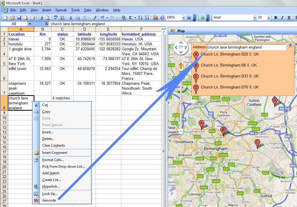
After you hae installed Geodesix you should see a map on the right and a ‘Geodesix’ tab in the ribbon.
If you don’t, run the troubleshooter
C:\Users\YOURLOGINNAME\AppData\Local\Geodesix\GeodesiX\TroubleShooter.exe
and send me the results
from where do i activate this add-in?
I’m supposing you’re using Windows 7.
In Windows explorer, double-click the zip file. You should see 2 files in there. Double-click the setup.exe.
I am a low watt bulb. I have downloaded the zip file, but do not understand how to install it. I also do not see any documentation on its usage, other than what you have listed above. Can you help me get it installed? I am using Excel 2007.
thanks
AMAZING plugin – hunted for a LONG time trying to figure out how to do this, couldn’t even figure it out with the $300 latest version of Microsoft Mappoint, google earth, google maps by itself, etc. THANK YOU!
Hi,
This is a great add-in, but I can only see and use the Show Map button on the GeodesiX ribbon bar.
How do I enable the Geodcode, GreatCircleDistance, and Travel UDF’s?
Thank you,
Robert
Greetings from Ohio, USA.
This is a really cool and (I expect) useful tool.
Thanks for posting!
The tool looks very interesting for my purpose. Only difference, I have the exact coordinates and need the country for output.
Is this possible with this tool?
Thanks Pierre