The map is blank !


This was resolved in release 3.0.2 (at least up to IE8).

  • Start Excel, Geodesix->Options->About and make sure you have version 3.0.2 or later.
  • In the Options->Advanced tab, make sure that the Googlemaps version is 3.6 or earlier.
  • Check these items
  • Browse the samples at Googlemaps API samples and try displaying geocoding-simple. If it doesn’t work, you’re probably using IE9 and I’m afraid I currently don’t have a solution.
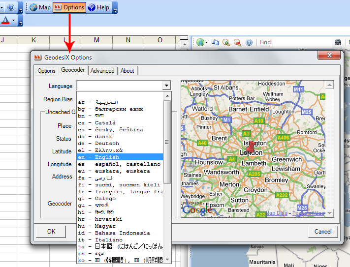
How do I display the map in languages other than English?


On the GeodesiX toolbar, click Options.
Select the Geocoder tab.
Choose the desired language. The map will refresh and display in the new language, if it is available.

As of this writing (April 2011), maps only display in English, Japanese, Korean and Russian.

However, the Geocoder does support most languages, as you can see by looking in the address box.

Are there any limits on Geocoding?


Yes. You should read GoogleMaps terms of use, in particular this question.

In a nutshell, you may not make more than 2’500 geocode requests in any 24-hour period and if you make too many requests in quick succession, the service will throttle (slow down).

GeodesiX enforces all the GoogleMaps limits and will slow down and eventually stop if you don’t respect the terms of use.

If you need to geocode large volumes, please don’t contact me, find a bulk geocoding service.

Can I display more than one place at a time on the map?


Yes. Here’s how:

  1. If the map pane isn’t currently displayed, click on the map icon in the GeodesiX toolbar to make the map pane appear
  2. In the map sheet dropdown, pick an empty worksheet (any old worksheet will do)
  3. When prompted if you want to create and Office Finder, click ‘yes’
  4. A new worksheet will be added to your workbook, containing a sample list, the capitals of the European Union
  5. During a few seconds, you will see the latitude and longitude fields being populated
  6. When they have all displayed, return to the map sheet dropdown and select the name of the worksheet that has just been created. A map of Europe will appear, with the countries’ flags on the capitals
  7. Click on the map to find the 5 nearest capitals. Hover over an orange line to see the distance
  8. Click on a flag to see details about the country

Take a moment to examine the formulas in the spreadsheet that was created for you. They illustrate how you can create maps with your own places, custom icons and popup texts.